


La Garde Freynet

soca
User
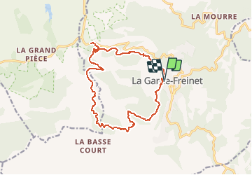

Length
16.3 km

Max alt
527 m

Uphill gradient
515 m
Km-Effort
23 km

Min alt
109 m

Downhill gradient
504 m
Boucle
Yes
Creation date :
2018-04-17 15:44:05.075
Updated on :
2018-04-17 15:44:05.075
5h04
Difficulty : Difficult

FREE GPS app for hiking
 SityTrail
IGN / Geographical institutes
SityTrail Plus
The world is yours!
About
Trail Walking of 16.3 km to be discovered at Provence-Alpes-Côte d'Azur, Var, La Garde-Freinet. This trail is proposed by soca.
Positioning
Country:
France
Region :
Provence-Alpes-Côte d'Azur
Department/Province :
Var
Municipality :
La Garde-Freinet
Location:
Unknown
Start:(Dec)
Start:(UTM)
294662 ; 4799422 (32T) N.
Comments